Relevant towns and neighbourhoods
Ubbena (buurtschap)Vries (woonkern)Zeijen (woonkern)Donderen (woonkern)Tile 12BZ1
Actueel Hoogtebestand Nederland
Point cloud
The aerial photograph closest to the acquisition date of the AHN iteration was overlaid on the point cloud to produce a colored version for visualisation purposes. Furthermore, for each point cloud a spatial index and textual summary, including elevation histogram, are provided. Please note that the images are not from the same flight, and may be years off. Therefore, small alignment errors and differences occur between them.
Zoom in on the map to see tiled versions (25 tiles of 1×1.25 km). Tiled versions typically fit into memory (RAM) are easier to handle and are especially suitable for parallel processing and Machine Learning.
| Version | Point cloud | Spatial index | Info | License | ||||
|---|---|---|---|---|---|---|---|---|
| AHN1 | Ground | 12bz1.laz | 15.1 MiB | 12bz1.lax | 18 kiB | 12bz1.txt | 9 kiB | Stuurgroep AHN, public domain |
| Non-ground | 12bz1.laz | 4.4 MiB | 12bz1.lax | 75 kiB | 12bz1.txt | 11 kiB | Stuurgroep AHN, public domain | |
| Merged | 12BZ1.LAZ | 19.5 MiB | 12BZ1.LAX | 33 kiB | 12BZ1.txt | 11 kiB | Stuurgroep AHN (merged product by GeoTiles) | |
| Colored | Available for sub-units only, zoom in to select. | Remixed by GeoTiles* | ||||||
| AHN2 | Ground | g12bz1.laz | 333.0 MiB | g12bz1.lax | 133 kiB | g12bz1.txt | 6 kiB | Stuurgroep AHN, public domain |
| Non-ground | u12bz1.laz | 189.3 MiB | u12bz1.lax | 100 kiB | u12bz1.txt | 15 kiB | Stuurgroep AHN, public domain | |
| Merged | 12BZ1.LAZ | 522.3 MiB | 12BZ1.LAX | 618 kiB | 12BZ1.txt | 16 kiB | Stuurgroep AHN (merged product by GeoTiles) | |
| Colored | Available for sub-units only, zoom in to select. | Remixed by GeoTiles* | ||||||
| AHN3 | Original | C_12BZ1.LAZ | 2.0 GiB | C_12BZ1.LAX | 1.8 MiB | C_12BZ1.txt | 16 kiB | Stuurgroep AHN, public domain |
| Colored | Available for sub-units only, zoom in to select. | Remixed by GeoTiles* | ||||||
| AHN4 | Original | C_12BZ1.LAZ | 3.7 GiB | C_12BZ1.LAX | 2.0 MiB | C_12BZ1.txt | 17 kiB | Het Waterschapshuis, public domain |
| Colored | (Partially) available for sub-units. | Remixed by GeoTiles* | ||||||
*The point cloud is in the public domain and the aerial photograph available under CC-BY. However, the colored point cloud is a new product created by GeoTiles.
File checksums (md5) are available for AHN1, AHN2, AHN3 and AHN4.
Raster
| Version | DSM | DTM ('maaiveld') | License | ||
|---|---|---|---|---|---|
| 5 meter | ½ meter | 5 meter | ½ meter | ||
| AHN1 | 12bz1.tif.zip | public domain | |||
| AHN2 | r12bz1.tif.zip | ahn2_5_12bz1.tif.zip | i12bz1.tif.zip | public domain * | |
| AHN3 | R5_12BZ1.zip | R_12BZ1.zip | M5_12BZ1.zip | M_12BZ1.zip | CC-0 |
| AHN4 | R5_12BZ1.zip | R_12BZ1.zip | M5_12BZ1.zip | M_12BZ1.zip | CC-0 [1, 2, 3, 4] |
Aerial photograph
| Year | Version | GeoTiff | Source | License | |
|---|---|---|---|---|---|
| 2016 | RGB | RGB_12BZ1.tiff | 61.4 MiB | Beeldmateriaal | CC-BY 4.0 |
| CIR | CIR_12BZ1.tiff | 57.3 MiB | CC-BY 4.0 | ||
| 2017 | RGB | RGB_12BZ1.tiff | 61.0 MiB | Beeldmateriaal | CC-BY 4.0 |
| CIR | CIR_12BZ1.tiff | 59.6 MiB | CC-BY 4.0 | ||
| 2018 | RGB | RGB_12BZ1.tiff | 58.0 MiB | Beeldmateriaal | CC-BY 4.0 |
| CIR | CIR_12BZ1.tiff | 56.0 MiB | CC-BY 4.0 | ||
| 2019 | RGB | RGB_12BZ1.tiff | 62.4 MiB | Beeldmateriaal | CC-BY 4.0 |
| CIR | CIR_12BZ1.tiff | 57.5 MiB | CC-BY 4.0 | ||
| 2020 | RGB | RGB_12BZ1.tiff | 61.0 MiB | Beeldmateriaal | CC-BY 4.0 |
| CIR | CIR_12BZ1.tiff | 57.3 MiB | CC-BY 4.0 | ||
| 2022 | RGB | RGB_12BZ1.tiff | 60.7 MiB | Beeldmateriaal | CC-BY 4.0 |
| CIR | CIR_12BZ1.tiff | 60.1 MiB | CC-BY 4.0 | ||
| 2023 | RGB | RGB_12BZ1.tiff | 66.5 MiB | Beeldmateriaal | CC-BY 4.0 |
| CIR | CIR_12BZ1.tiff | 67.1 MiB | CC-BY 4.0 | ||
Sub-tiles 12BZ1
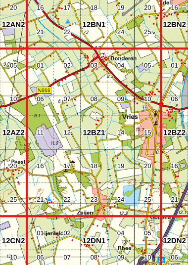
Image adapted from Kadaster TOPraster and OpenTopo.
Actueel Hoogtebestand Nederland
Point cloud
These sub-tiles of 1×1.25 km are clipped from the original point cloud. Goal is to enable distributed processing of the point cloud. Therefore, a 25 m overlap to the neighbouring (sub-)tiles is added. Thanks to the overlap between sub-tiles, the sub-tiles can be processed independently and therefore parallel.
All other data sets on this website are only available in the main tiling schema.
| Tile | Version | Point cloud | Spatial index | Info | Residential areas | License | |||
|---|---|---|---|---|---|---|---|---|---|
| 12BZ1_01 | AHN1 | 12BZ1_01.LAZ | 1.4 MiB | 12BZ1_01.LAX | 5 kiB | 12BZ1_01.txt | 9 kiB | AHN (stuurgroep AHN, public data) and aerial photograph (Beeldmateriaal, CC-BY) remixed by GeoTiles, CC-BY | |
| AHN2 | 12BZ1_01.LAZ | 41.4 MiB | 12BZ1_01.LAX | 25 kiB | 12BZ1_01.txt | 11 kiB | |||
| AHN3 | 12BZ1_01.LAZ | 88.9 MiB | 12BZ1_01.LAX | 77 kiB | 12BZ1_01.txt | 13 kiB | |||
| AHN4 | 12BZ1_01.LAZ | 170.8 MiB | 12BZ1_01.LAX | 100 kiB | 12BZ1_01.txt | 14 kiB | |||
| 12BZ1_02 | AHN1 | 12BZ1_02.LAZ | 1.4 MiB | 12BZ1_02.LAX | 5 kiB | 12BZ1_02.txt | 9 kiB | AHN (stuurgroep AHN, public data) and aerial photograph (Beeldmateriaal, CC-BY) remixed by GeoTiles, CC-BY | |
| AHN2 | 12BZ1_02.LAZ | 43.1 MiB | 12BZ1_02.LAX | 25 kiB | 12BZ1_02.txt | 11 kiB | |||
| AHN3 | 12BZ1_02.LAZ | 93.2 MiB | 12BZ1_02.LAX | 79 kiB | 12BZ1_02.txt | 12 kiB | |||
| AHN4 | 12BZ1_02.LAZ | 175.9 MiB | 12BZ1_02.LAX | 99 kiB | 12BZ1_02.txt | 13 kiB | |||
| 12BZ1_03 | AHN1 | 12BZ1_03.LAZ | 1.4 MiB | 12BZ1_03.LAX | 5 kiB | 12BZ1_03.txt | 10 kiB | Donderen | AHN (stuurgroep AHN, public data) and aerial photograph (Beeldmateriaal, CC-BY) remixed by GeoTiles, CC-BY |
| AHN2 | 12BZ1_03.LAZ | 51.8 MiB | 12BZ1_03.LAX | 29 kiB | 12BZ1_03.txt | 12 kiB | |||
| AHN3 | 12BZ1_03.LAZ | 101.1 MiB | 12BZ1_03.LAX | 85 kiB | 12BZ1_03.txt | 13 kiB | |||
| AHN4 | 12BZ1_03.LAZ | 199.2 MiB | 12BZ1_03.LAX | 100 kiB | 12BZ1_03.txt | 15 kiB | |||
| 12BZ1_04 | AHN1 | 12BZ1_04.LAZ | 1.4 MiB | 12BZ1_04.LAX | 4 kiB | 12BZ1_04.txt | 9 kiB | Donderen | AHN (stuurgroep AHN, public data) and aerial photograph (Beeldmateriaal, CC-BY) remixed by GeoTiles, CC-BY |
| AHN2 | 12BZ1_04.LAZ | 47.0 MiB | 12BZ1_04.LAX | 26 kiB | 12BZ1_04.txt | 11 kiB | |||
| AHN3 | 12BZ1_04.LAZ | 97.6 MiB | 12BZ1_04.LAX | 84 kiB | 12BZ1_04.txt | 13 kiB | |||
| AHN4 | 12BZ1_04.LAZ | 183.7 MiB | 12BZ1_04.LAX | 100 kiB | 12BZ1_04.txt | 14 kiB | |||
| 12BZ1_05 | AHN1 | 12BZ1_05.LAZ | 1.4 MiB | 12BZ1_05.LAX | 4 kiB | 12BZ1_05.txt | 8 kiB | AHN (stuurgroep AHN, public data) and aerial photograph (Beeldmateriaal, CC-BY) remixed by GeoTiles, CC-BY | |
| AHN2 | 12BZ1_05.LAZ | 45.8 MiB | 12BZ1_05.LAX | 25 kiB | 12BZ1_05.txt | 10 kiB | |||
| AHN3 | 12BZ1_05.LAZ | 100.9 MiB | 12BZ1_05.LAX | 87 kiB | 12BZ1_05.txt | 11 kiB | |||
| AHN4 | 12BZ1_05.LAZ | 182.3 MiB | 12BZ1_05.LAX | 100 kiB | 12BZ1_05.txt | 13 kiB | |||
| 12BZ1_06 | AHN1 | 12BZ1_06.LAZ | 1.4 MiB | 12BZ1_06.LAX | 5 kiB | 12BZ1_06.txt | 12 kiB | AHN (stuurgroep AHN, public data) and aerial photograph (Beeldmateriaal, CC-BY) remixed by GeoTiles, CC-BY | |
| AHN2 | 12BZ1_06.LAZ | 64.7 MiB | 12BZ1_06.LAX | 29 kiB | 12BZ1_06.txt | 15 kiB | |||
| AHN3 | 12BZ1_06.LAZ | 150.1 MiB | 12BZ1_06.LAX | 89 kiB | 12BZ1_06.txt | 17 kiB | |||
| AHN4 | 12BZ1_06.LAZ | 270.5 MiB | 12BZ1_06.LAX | 100 kiB | 12BZ1_06.txt | 18 kiB | |||
| 12BZ1_07 | AHN1 | 12BZ1_07.LAZ | 1.5 MiB | 12BZ1_07.LAX | 5 kiB | 12BZ1_07.txt | 10 kiB | AHN (stuurgroep AHN, public data) and aerial photograph (Beeldmateriaal, CC-BY) remixed by GeoTiles, CC-BY | |
| AHN2 | 12BZ1_07.LAZ | 43.8 MiB | 12BZ1_07.LAX | 28 kiB | 12BZ1_07.txt | 11 kiB | |||
| AHN3 | 12BZ1_07.LAZ | 96.4 MiB | 12BZ1_07.LAX | 79 kiB | 12BZ1_07.txt | 13 kiB | |||
| AHN4 | 12BZ1_07.LAZ | 180.8 MiB | 12BZ1_07.LAX | 100 kiB | 12BZ1_07.txt | 14 kiB | |||
| 12BZ1_08 | AHN1 | 12BZ1_08.LAZ | 1.4 MiB | 12BZ1_08.LAX | 5 kiB | 12BZ1_08.txt | 9 kiB | AHN (stuurgroep AHN, public data) and aerial photograph (Beeldmateriaal, CC-BY) remixed by GeoTiles, CC-BY | |
| AHN2 | 12BZ1_08.LAZ | 44.7 MiB | 12BZ1_08.LAX | 25 kiB | 12BZ1_08.txt | 11 kiB | |||
| AHN3 | 12BZ1_08.LAZ | 106.0 MiB | 12BZ1_08.LAX | 89 kiB | 12BZ1_08.txt | 12 kiB | |||
| AHN4 | 12BZ1_08.LAZ | 182.7 MiB | 12BZ1_08.LAX | 100 kiB | 12BZ1_08.txt | 13 kiB | |||
| 12BZ1_09 | AHN1 | 12BZ1_09.LAZ | 1.4 MiB | 12BZ1_09.LAX | 5 kiB | 12BZ1_09.txt | 9 kiB | AHN (stuurgroep AHN, public data) and aerial photograph (Beeldmateriaal, CC-BY) remixed by GeoTiles, CC-BY | |
| AHN2 | 12BZ1_09.LAZ | 51.1 MiB | 12BZ1_09.LAX | 29 kiB | 12BZ1_09.txt | 11 kiB | |||
| AHN3 | 12BZ1_09.LAZ | 116.3 MiB | 12BZ1_09.LAX | 85 kiB | 12BZ1_09.txt | 13 kiB | |||
| AHN4 | 12BZ1_09.LAZ | 204.1 MiB | 12BZ1_09.LAX | 100 kiB | 12BZ1_09.txt | 14 kiB | |||
| 12BZ1_10 | AHN1 | 12BZ1_10.LAZ | 1.5 MiB | 12BZ1_10.LAX | 4 kiB | 12BZ1_10.txt | 11 kiB | Vries | AHN (stuurgroep AHN, public data) and aerial photograph (Beeldmateriaal, CC-BY) remixed by GeoTiles, CC-BY |
| AHN2 | 12BZ1_10.LAZ | 63.7 MiB | 12BZ1_10.LAX | 32 kiB | 12BZ1_10.txt | 14 kiB | |||
| AHN3 | 12BZ1_10.LAZ | 149.8 MiB | 12BZ1_10.LAX | 92 kiB | 12BZ1_10.txt | 15 kiB | |||
| AHN4 | 12BZ1_10.LAZ | 257.6 MiB | 12BZ1_10.LAX | 100 kiB | 12BZ1_10.txt | 15 kiB | |||
| 12BZ1_11 | AHN1 | 12BZ1_11.LAZ | 1.5 MiB | 12BZ1_11.LAX | 5 kiB | 12BZ1_11.txt | 12 kiB | AHN (stuurgroep AHN, public data) and aerial photograph (Beeldmateriaal, CC-BY) remixed by GeoTiles, CC-BY | |
| AHN2 | 12BZ1_11.LAZ | 78.7 MiB | 12BZ1_11.LAX | 34 kiB | 12BZ1_11.txt | 15 kiB | |||
| AHN3 | 12BZ1_11.LAZ | 181.9 MiB | 12BZ1_11.LAX | 94 kiB | 12BZ1_11.txt | 17 kiB | |||
| AHN4 | 12BZ1_11.LAZ | 291.0 MiB | 12BZ1_11.LAX | 100 kiB | 12BZ1_11.txt | 18 kiB | |||
| 12BZ1_12 | AHN1 | 12BZ1_12.LAZ | 1.5 MiB | 12BZ1_12.LAX | 5 kiB | 12BZ1_12.txt | 9 kiB | AHN (stuurgroep AHN, public data) and aerial photograph (Beeldmateriaal, CC-BY) remixed by GeoTiles, CC-BY | |
| AHN2 | 12BZ1_12.LAZ | 45.8 MiB | 12BZ1_12.LAX | 26 kiB | 12BZ1_12.txt | 11 kiB | |||
| AHN3 | 12BZ1_12.LAZ | 101.0 MiB | 12BZ1_12.LAX | 89 kiB | 12BZ1_12.txt | 12 kiB | |||
| AHN4 | 12BZ1_12.LAZ | 170.5 MiB | 12BZ1_12.LAX | 99 kiB | 12BZ1_12.txt | 14 kiB | |||
| 12BZ1_13 | AHN1 | 12BZ1_13.LAZ | 1.4 MiB | 12BZ1_13.LAX | 5 kiB | 12BZ1_13.txt | 9 kiB | AHN (stuurgroep AHN, public data) and aerial photograph (Beeldmateriaal, CC-BY) remixed by GeoTiles, CC-BY | |
| AHN2 | 12BZ1_13.LAZ | 42.5 MiB | 12BZ1_13.LAX | 25 kiB | 12BZ1_13.txt | 11 kiB | |||
| AHN3 | 12BZ1_13.LAZ | 101.1 MiB | 12BZ1_13.LAX | 86 kiB | 12BZ1_13.txt | 12 kiB | |||
| AHN4 | 12BZ1_13.LAZ | 179.0 MiB | 12BZ1_13.LAX | 99 kiB | 12BZ1_13.txt | 13 kiB | |||
| 12BZ1_14 | AHN1 | 12BZ1_14.LAZ | 1.4 MiB | 12BZ1_14.LAX | 5 kiB | 12BZ1_14.txt | 10 kiB | AHN (stuurgroep AHN, public data) and aerial photograph (Beeldmateriaal, CC-BY) remixed by GeoTiles, CC-BY | |
| AHN2 | 12BZ1_14.LAZ | 55.3 MiB | 12BZ1_14.LAX | 28 kiB | 12BZ1_14.txt | 12 kiB | |||
| AHN3 | 12BZ1_14.LAZ | 126.0 MiB | 12BZ1_14.LAX | 87 kiB | 12BZ1_14.txt | 13 kiB | |||
| AHN4 | 12BZ1_14.LAZ | 233.3 MiB | 12BZ1_14.LAX | 99 kiB | 12BZ1_14.txt | 15 kiB | |||
| 12BZ1_15 | AHN1 | 12BZ1_15.LAZ | 1.5 MiB | 12BZ1_15.LAX | 4 kiB | 12BZ1_15.txt | 11 kiB | Vries | AHN (stuurgroep AHN, public data) and aerial photograph (Beeldmateriaal, CC-BY) remixed by GeoTiles, CC-BY |
| AHN2 | 12BZ1_15.LAZ | 73.6 MiB | 12BZ1_15.LAX | 34 kiB | 12BZ1_15.txt | 13 kiB | |||
| AHN3 | 12BZ1_15.LAZ | 155.3 MiB | 12BZ1_15.LAX | 96 kiB | 12BZ1_15.txt | 14 kiB | |||
| AHN4 | 12BZ1_15.LAZ | 272.9 MiB | 12BZ1_15.LAX | 100 kiB | 12BZ1_15.txt | 15 kiB | |||
| 12BZ1_16 | AHN1 | 12BZ1_16.LAZ | 1.4 MiB | 12BZ1_16.LAX | 5 kiB | 12BZ1_16.txt | 12 kiB | AHN (stuurgroep AHN, public data) and aerial photograph (Beeldmateriaal, CC-BY) remixed by GeoTiles, CC-BY | |
| AHN2 | 12BZ1_16.LAZ | 55.7 MiB | 12BZ1_16.LAX | 32 kiB | 12BZ1_16.txt | 14 kiB | |||
| AHN3 | 12BZ1_16.LAZ | 115.3 MiB | 12BZ1_16.LAX | 87 kiB | 12BZ1_16.txt | 16 kiB | |||
| AHN4 | 12BZ1_16.LAZ | 204.1 MiB | 12BZ1_16.LAX | 100 kiB | 12BZ1_16.txt | 17 kiB | |||
| 12BZ1_17 | AHN1 | 12BZ1_17.LAZ | 1.4 MiB | 12BZ1_17.LAX | 5 kiB | 12BZ1_17.txt | 10 kiB | AHN (stuurgroep AHN, public data) and aerial photograph (Beeldmateriaal, CC-BY) remixed by GeoTiles, CC-BY | |
| AHN2 | 12BZ1_17.LAZ | 54.0 MiB | 12BZ1_17.LAX | 28 kiB | 12BZ1_17.txt | 12 kiB | |||
| AHN3 | 12BZ1_17.LAZ | 133.8 MiB | 12BZ1_17.LAX | 89 kiB | 12BZ1_17.txt | 14 kiB | |||
| AHN4 | 12BZ1_17.LAZ | 233.9 MiB | 12BZ1_17.LAX | 100 kiB | 12BZ1_17.txt | 15 kiB | |||
| 12BZ1_18 | AHN1 | 12BZ1_18.LAZ | 1.4 MiB | 12BZ1_18.LAX | 5 kiB | 12BZ1_18.txt | 11 kiB | AHN (stuurgroep AHN, public data) and aerial photograph (Beeldmateriaal, CC-BY) remixed by GeoTiles, CC-BY | |
| AHN2 | 12BZ1_18.LAZ | 54.6 MiB | 12BZ1_18.LAX | 29 kiB | 12BZ1_18.txt | 13 kiB | |||
| AHN3 | 12BZ1_18.LAZ | 136.5 MiB | 12BZ1_18.LAX | 84 kiB | 12BZ1_18.txt | 14 kiB | |||
| AHN4 | 12BZ1_18.LAZ | 237.8 MiB | 12BZ1_18.LAX | 100 kiB | 12BZ1_18.txt | 15 kiB | |||
| 12BZ1_19 | AHN1 | 12BZ1_19.LAZ | 1.4 MiB | 12BZ1_19.LAX | 5 kiB | 12BZ1_19.txt | 9 kiB | Ubbena | AHN (stuurgroep AHN, public data) and aerial photograph (Beeldmateriaal, CC-BY) remixed by GeoTiles, CC-BY |
| AHN2 | 12BZ1_19.LAZ | 40.3 MiB | 12BZ1_19.LAX | 24 kiB | 12BZ1_19.txt | 11 kiB | |||
| AHN3 | 12BZ1_19.LAZ | 94.6 MiB | 12BZ1_19.LAX | 82 kiB | 12BZ1_19.txt | 12 kiB | |||
| AHN4 | 12BZ1_19.LAZ | 170.9 MiB | 12BZ1_19.LAX | 100 kiB | 12BZ1_19.txt | 14 kiB | |||
| 12BZ1_20 | AHN1 | 12BZ1_20.LAZ | 1.5 MiB | 12BZ1_20.LAX | 4 kiB | 12BZ1_20.txt | 10 kiB | Ubbena, Vries | AHN (stuurgroep AHN, public data) and aerial photograph (Beeldmateriaal, CC-BY) remixed by GeoTiles, CC-BY |
| AHN2 | 12BZ1_20.LAZ | 57.7 MiB | 12BZ1_20.LAX | 32 kiB | 12BZ1_20.txt | 12 kiB | |||
| AHN3 | 12BZ1_20.LAZ | 128.8 MiB | 12BZ1_20.LAX | 90 kiB | 12BZ1_20.txt | 14 kiB | |||
| AHN4 | 12BZ1_20.LAZ | 225.2 MiB | 12BZ1_20.LAX | 100 kiB | 12BZ1_20.txt | 15 kiB | |||
| 12BZ1_21 | AHN1 | 12BZ1_21.LAZ | 1.4 MiB | 12BZ1_21.LAX | 5 kiB | 12BZ1_21.txt | 10 kiB | AHN (stuurgroep AHN, public data) and aerial photograph (Beeldmateriaal, CC-BY) remixed by GeoTiles, CC-BY | |
| AHN2 | 12BZ1_21.LAZ | 52.0 MiB | 12BZ1_21.LAX | 27 kiB | 12BZ1_21.txt | 16 kiB | |||
| AHN3 | 12BZ1_21.LAZ | 117.9 MiB | 12BZ1_21.LAX | 82 kiB | 12BZ1_21.txt | 17 kiB | |||
| AHN4 | 12BZ1_21.LAZ | 194.3 MiB | 12BZ1_21.LAX | 99 kiB | 12BZ1_21.txt | 18 kiB | |||
| 12BZ1_22 | AHN1 | 12BZ1_22.LAZ | 1.4 MiB | 12BZ1_22.LAX | 4 kiB | 12BZ1_22.txt | 10 kiB | AHN (stuurgroep AHN, public data) and aerial photograph (Beeldmateriaal, CC-BY) remixed by GeoTiles, CC-BY | |
| AHN2 | 12BZ1_22.LAZ | 55.7 MiB | 12BZ1_22.LAX | 30 kiB | 12BZ1_22.txt | 12 kiB | |||
| AHN3 | 12BZ1_22.LAZ | 129.8 MiB | 12BZ1_22.LAX | 87 kiB | 12BZ1_22.txt | 13 kiB | |||
| AHN4 | 12BZ1_22.LAZ | 225.8 MiB | 12BZ1_22.LAX | 100 kiB | 12BZ1_22.txt | 14 kiB | |||
| 12BZ1_23 | AHN1 | 12BZ1_23.LAZ | 1.5 MiB | 12BZ1_23.LAX | 5 kiB | 12BZ1_23.txt | 10 kiB | Zeijen, Ubbena | AHN (stuurgroep AHN, public data) and aerial photograph (Beeldmateriaal, CC-BY) remixed by GeoTiles, CC-BY |
| AHN2 | 12BZ1_23.LAZ | 58.3 MiB | 12BZ1_23.LAX | 30 kiB | 12BZ1_23.txt | 12 kiB | |||
| AHN3 | 12BZ1_23.LAZ | 129.5 MiB | 12BZ1_23.LAX | 87 kiB | 12BZ1_23.txt | 15 kiB | |||
| AHN4 | 12BZ1_23.LAZ | 233.0 MiB | 12BZ1_23.LAX | 100 kiB | 12BZ1_23.txt | 16 kiB | |||
| 12BZ1_24 | AHN1 | 12BZ1_24.LAZ | 1.2 MiB | 12BZ1_24.LAX | 5 kiB | 12BZ1_24.txt | 9 kiB | Ubbena, Zeijen | AHN (stuurgroep AHN, public data) and aerial photograph (Beeldmateriaal, CC-BY) remixed by GeoTiles, CC-BY |
| AHN2 | 12BZ1_24.LAZ | 43.9 MiB | 12BZ1_24.LAX | 26 kiB | 12BZ1_24.txt | 11 kiB | |||
| AHN3 | 12BZ1_24.LAZ | 111.1 MiB | 12BZ1_24.LAX | 83 kiB | 12BZ1_24.txt | 12 kiB | |||
| AHN4 | 12BZ1_24.LAZ | 180.4 MiB | 12BZ1_24.LAX | 90 kiB | 12BZ1_24.txt | 13 kiB | |||
| 12BZ1_25 | AHN1 | 12BZ1_25.LAZ | 1.4 MiB | 12BZ1_25.LAX | 4 kiB | 12BZ1_25.txt | 10 kiB | Ubbena | AHN (stuurgroep AHN, public data) and aerial photograph (Beeldmateriaal, CC-BY) remixed by GeoTiles, CC-BY |
| AHN2 | 12BZ1_25.LAZ | 43.3 MiB | 12BZ1_25.LAX | 25 kiB | 12BZ1_25.txt | 11 kiB | |||
| AHN3 | 12BZ1_25.LAZ | 100.5 MiB | 12BZ1_25.LAX | 84 kiB | 12BZ1_25.txt | 13 kiB | |||
| AHN4 | 12BZ1_25.LAZ | 166.9 MiB | 12BZ1_25.LAX | 94 kiB | 12BZ1_25.txt | 14 kiB | |||